Log in
All resources
Create a design
9,296 Free Artworks of Map Collection
bibliothèque nationale de france
british museum
augustine ryther
bowes playing cards bm 1938,0709.57.1-60
pasteboard
elizabeth i, queen of england
maps of the islands of greece by marco boschini (1658)
marco boschini
national library of poland
atlas ou representation du monde universel t. 2 (1633)
atlas ou representation du monde universel t. 2 (1633)
maps by hendrik hondius the younger
atlas ou representation du monde universel t. 2 (1633)
maps by hendrik hondius the younger
atlas ou representation du monde universel t. 2 (1633)
maps by hendrik hondius the younger
atlas ou representation du monde universel t. 2 (1633)
maps of the duchy of mantua
atlas ou representation du monde universel t. 2 (1633)
old maps of nassau
atlas ou representation du monde universel t. 2 (1633)
old maps of east frisia
atlas ou representation du monde universel t. 2 (1633)
maps of the duchy of milan
atlas ou representation du monde universel t. 2 (1633)
maps by hendrik hondius the younger
atlas ou representation du monde universel t. 2 (1633)
17th-century maps of chile
1660 paintings
baroque
drawings by leonardo da vinci in the royal collection of the united kingdom
high renaissance,renaissance
eran laor cartographic collection
18th-century maps of jerusalem
maps of africa by mercator-hondius
eran laor cartographic collection
catalan atlas
mansa musa
maps of guinea by mercator-hondius
guinea (region)
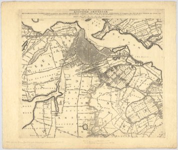
maps in the stadsarchief amsterdam
hendrik de leth
dutch paintings in the saint louis art museum
genre paintings by nicolaes maes
atlas maior, vol 3 (germany) - joan blaeu, 1667 - bl 114.h(star).3
collections of the nederlands scheepvaartmuseum
map collection of leibniz-institut für länderkunde
maps of portugal by fernando álvares seco
dutch paintings in the saint louis art museum
genre paintings by nicolaes maes
romanticism
john martin
atlas maior, vol 2 (sweden, russia, poland, eastern europe, and greece) - joan blaeu, 1667 - bl 114.h(star).2
copper engraving print
atlas maior, vol 3 (germany) - joan blaeu, 1667 - bl 114.h(star).3
celeberrimi fluvii albis nova delineatio by willem janszoon blaeu
engravings of birds in the rijksmuseum amsterdam
covens en mortier
maps by pieter mortier
maps from gallica
maps of ancient israel by philippe de la rué
henri le roy (1579-)
maps of kraków by joris hoefnagel
joris hoefnagel
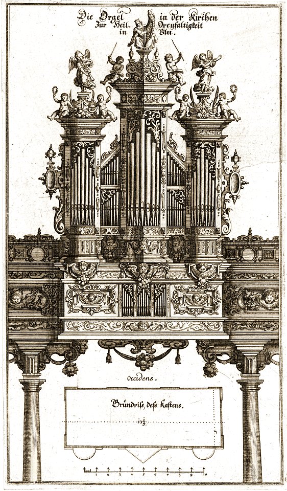
pipe organs in ulm
baroque
pipe organs in ulm
baroque
postcards in bibliothèque municipale de nancy
limédia galeries - b543956101
les conquêtes de l'empereur de chine (palace museum)
the submission of the ili
les conquêtes de l'empereur de chine (palace museum)
the submission of the ili
historical collections of the state of new jersey (1852)
1852 maps of the united states
maps by emanuel bowen
1744 fleurons
ancona (galleria delle carte geografiche)
bowes playing cards bm 1938,0709.57.1-60
augustine ryther
bowes playing cards bm 1938,0709.57.1-60
augustine ryther
bowes playing cards bm 1938,0709.57.1-60
augustine ryther
bowes playing cards bm 1938,0709.57.1-60
augustine ryther
bowes playing cards bm 1938,0709.57.1-60
augustine ryther
bowes playing cards bm 1938,0709.57.1-60
augustine ryther
bowes playing cards bm 1938,0709.57.1-60
augustine ryther
bowes playing cards bm 1938,0709.57.1-60
augustine ryther
bowes playing cards bm 1938,0709.57.1-60
augustine ryther
bowes playing cards bm 1938,0709.57.1-60
augustine ryther
bowes playing cards bm 1938,0709.57.1-60
augustine ryther
bowes playing cards bm 1938,0709.57.1-60
augustine ryther
bowes playing cards bm 1938,0709.57.1-60
augustine ryther
bowes playing cards bm 1938,0709.57.1-60
augustine ryther
bowes playing cards bm 1938,0709.57.1-60
augustine ryther
bowes playing cards bm 1938,0709.57.1-60
augustine ryther
geographia universalis (1545) in the british museum
german renaissance,northern renaissance
maps of portugal by fernando álvares seco
eran laor cartographic collection
historical collections of the state of new jersey (1852)
maps of newark, new jersey
burlington, new jersey in the 18th century
maps of burlington, new jersey
maps in the stadsarchief amsterdam
daniel stoopendaal
maps in the stadsarchief amsterdam
daniël veelwaard (i)
maps in the stadsarchief amsterdam
hendrik de leth
historical collections of the state of new jersey (1845)
maps of burlington, new jersey
maps of meldorf by braun & hogenberg
maps of heide by braun & hogenberg
maps of the islands of greece by marco boschini (1658)
old maps of amorgos
1667 sanson map of africa
1702 maps of africa
maps of bourges by braun & hogenberg
maps of orléans by joris hoefnagel
maps of the islands of greece by marco boschini (1658)
old maps of naxos
maps by willem and johannes blaeu
17th-century maps of xaintonge
maps of liège by baptista van doetecum
maps by abraham ortelius
maps of dordrecht by braun & hogenberg
bibliothèque nationale de france
maps of ancient italy by philipp clüver
old maps of the alps
maps by willem and johannes blaeu
old maps of capitanata
maps of the islands of greece by marco boschini (1658)
old maps of tilos
maps by willem and johannes blaeu
17th-century maps of abruzzo
maps of the islands of greece by marco boschini (1658)
old maps of kalymnos
maps of the islands of greece by marco boschini (1658)
old maps of nisyros
a topographical map of the county of berks (1761)
bibliothèque nationale de france
maps of the islands of greece by marco boschini (1658)
old maps of ios
maps of the islands of greece by marco boschini (1658)
old maps of anafi
maps of the islands of greece by marco boschini (1658)
old maps of mykonos
maps of vienne by braun & hogenberg
maps of lyon by braun & hogenberg
maps by matthäus merian
baroque
maps of the islands of greece by marco boschini (1658)
old maps of patmos
bibliothèque nationale de france
sanson maps of the holy land
maps of the islands of greece by marco boschini (1658)
old maps of leros
arnold van langren map of southwest africa
1596 maps of africa
maps of the islands of greece by marco boschini (1658)
old maps of kos
a topographical map of the county of berks (1761)
bibliothèque nationale de france
maps of the islands of greece by marco boschini (1658)
old maps of kythnos
maps of mons (hainaut) by braun & hogenberg
maps of arras by braun & hogenberg
17th-century maps of the holy roman empire
maps by pieter van der keere
maps of the islands of greece by marco boschini (1658)
old maps of alonissos
a topographical map of the county of berks (1761)
bibliothèque nationale de france
maps by willem and johannes blaeu
old maps of berry
maps of the islands of greece by marco boschini (1658)
old maps of andros
maps of budapest by braun & hogenberg
maps of vienna by braun & hogenberg
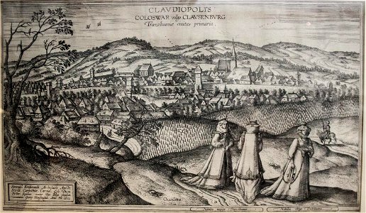
maps of cluj-napoca by braun & hogenberg
copper engraving print on paper
nypl general research division
voyage en perse
maps of the holy land by mercator-hondius
eran laor cartographic collection
etchings by charles meryon in the cleveland museum of art
meryon (delteil 062)
german renaissance,humanism
1490s maps of istanbul
fürstlich jülich‘sche hochzeit
old maps of düsseldorf
civitates orbis terrarvm, liber primvs (1577)
maps of mons (hainaut)
5701 - 5800 of 9,296
Next page
/ 93